Santiago, Chile
Overview
Santiago, the capital of Chile, has a population of 6 million inhabitants and lies about 110 Km (68.4 Milles) from the Pacific Ocean coast. The Santiago Metro has 4 lines and one branch with a length of 84.5 Km (52.6 Miles) and 92 stations.
The subway has a daily ridership of 2.5 million people since the implementation of the Transantiago System, which integrated the train and bus network of the Central Region of Chile.
64 stations are underground, 3 at open excavation, 10 at grade, and 15 elevated. All the lines except Lines 4 and its branch 4A are operated trains with rubber tyres like some lines in Paris and the subways of Mexico City and Montreal.
From the Alameda Station (Central Railroad Station), toward the south, runs a suburban or regional railroad called Metrotren, with a length of 135 Km (83.9 Milles) and 18 stations. The Alameda Station is conected with the subway in the Estacion Central of the Line 1.
On Lines 4 and 5 there is a skip-stop express service in the peak hours (6:00 to 9:00 in the morning and 18:00 to 21:00 in the evening). The trains are marked green and red, which stop at alternate and some shared stations.
At the present, two new stretches are under construction, one is a extension of the Line 1 to the East with a length of 3.8 Km (2.4 Miles) and 3 stations, all underground, with another possible station to be added later; and a new stretch in the West and Southwest of the city to extend the Line 5, with length of 14.2 Km (8.8 Miles), 11 stations, part underground and part elevated. Additionally, a new station is being built in the south stretch of the Line 4.
- Metro Line 1. Runs from West to East with a length of 16.0 Km (10.0 Miles), 24 stations (21 underground, 3 open excavation).
- Metro Line 2. Runs from West to East in the Central Zone of the city and turns towards the South with a length of 20.6 Km (12.8 Miles), 22 stations (18 are underground, 4 at grade).
- Metro Line 4. Runs in the East and South of the city with a length of 24.7 Km (15.4 Miles), 22 stations (12 underground, 2 at grade, and 8 elevated).
- Metro Line 4A. Operated as a branch of the Line 4, runs from East to West in the South part of the city with a length of 7.7 Km (4.8 Miles), 6 stations (2 underground, 4 at grade).
- Metro Line 5. Runs from North to South with a length of 15.5 Km (9.6 Miles), 18 stations (11 underground, 7 elevated).
Photos By Location
Line 1
Photo locations: San Pablo, Neptuno, Pajaritos, Las Rejas, Ecuador, San Alberto Hurtado, Universidad de Santiago, Estación Central, Unión Latinoamericana, República, Los Héroes, La Moneda, Universidad de Chile, Santa Lucía, Universidad Católica, Baquedano, Salvador, Manuel Montt, Pedro de Valdivia, Los Leones, Tobalaba, El Golf, Alcántara, Escuela Militar, Manquehue, Hernando de Magallanes, Plaza Los Domínicos
Line 2
Photo locations: Vespucio Norte, Zapadores, Dorsal, Einstein, Cementerios, Cerro Blanco, Patronato, Puente Cal y Canto, Santa Ana, Los Héroes, Toesca, Parque O'Higgins, Rondizzoni, Franklin, El Llano, San Miguel, Lo Vial, Departamental, Ciudad del Niño, Lo Ovalle, El Parrón, La Cisterna
Line 4
Photo locations: Tobalaba, Cristóbal Colón, Francisco Bilbao, Príncipe de Gales, Simón Bolívar, Plaza Egaña, Los Orientales, Grecia, Los Presidentes, Quilín, Las Torres, Macul, Vicuña Mackenna, Vicente Valdés, Rojas Magallanes, Trinidad, San José de la Estrella, Los Quillayes, Elisa Correa, Hospital Sótero del Río, Protectora de la Infancia, Las Mercedes, Plaza de Puente Alto
Line 4a
Photo locations: La Cisterna, San Ramón, Santa Rosa, La Granja, Santa Julia, Vicuña Mackenna
Line 5
Photo locations: Plaza de Maipú, Santiago Bueras, El Sol, Monte Tabor, Las Parcelas, Laguna Sur, Barrancas, Pudahuel, San Pablo, Lo Prado, Blanqueado, Gruta de Lourdes, Quinta Normal, Cumming, Santa Ana, Plaza de Armas, Bellas Artes, Baquedano, Parque Bustamante, Santa Isabel, Irarrázaval, Ñuble, Rodrigo de Araya, Carlos Valdovinos, Camino Agrícola, San Joaquín, Pedrero, Mirador, Bellavista de La Florida, Vicente Valdés
Photo Gallery
| Five Random Images | ||||
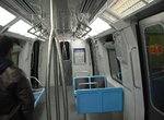 Image 101892 (178k, 1044x788) Photo by: Jorge Arturo Monzón Abarca | 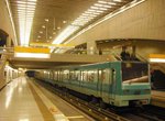 Image 101904 (206k, 1044x788) Photo by: Jorge Arturo Monzón Abarca Location: Vespucio Norte |  Image 101954 (182k, 1044x788) Photo by: Jorge Arturo Monzón Abarca Location: Trinidad | 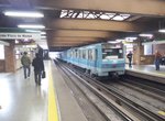 Image 139843 (313k, 1044x788) Photo by: David Pirmann Location: Santa Ana |  Image 139847 (326k, 1044x788) Photo by: David Pirmann Location: Santa Ana |
Page Credits
By Jorge Arturo Monzón Abarca.