IRT East Side Line
Overview
The IRT line on the East Side of Manhattan is made up of portions of several different subway construction contracts, including the 1904 Contract I "First Subway" from City Hall to 33rd Street, three 1905 Contract II Brooklyn Extension stations, and, from Grand Central northward, eleven 1918 Contract III, or "Dual Contracts" stations.
The Contract I and Dual Contracts construction is covered in-depth elsewhere on this site (The First Subway and The Dual Contracts), so this overview will consist of a few brief notes.
The contract drawings for the "First Subway" were completed in 1898 by chief engineer William Barclay Parsons. The engineering and design of the Contract I subway was divided into 15 sub-sections. The portion of the work included in today's East Side line include:
Section 1, Ann Street north to the center of Chambers Street, 0.5 miles of route including the City Hall station and loop, and Brooklyn Bridge station. The work included two tail tracks in a two track structure ending just north of Ann Street, for the switching back of express trains, and two tail tracks and the City Hall loop for layup and turnback of the local trains. The "express" tail tracks would be later used to connect the Contract II Brooklyn Extension subway work from Broadway. The Contract I subway's groundbreaking took place at City Hall on March 24, 1900 but actual construction on this segment didn't start until March, 1901.
Section 2, Center of Chambers Street north to the center of Great Jones Street, a four track subway running 1.13 miles under Elm Street (today's Lafayette Street). Cut and cover construction. Stations included: Worth Street (now closed), Canal Street, Spring Street, and Bleecker Street. At Spring Street there was a center siding track making the width of the subway at this point five tracks. Construction commenced July 10, 1900, and encountered some trouble near Pearl Street at the site of the old filled-in Collect Pond.
Section 3, Center of Great Jones Street north to approximately 34th Street, a four track subway running 1.5 miles under Elm Street (Lafayette Street), Fourth Avenue, and today's Park Avenue South and Park Avenue. Cut and cover construction. Stations located at: Astor Place, 14th Street (express), 18th Street (now closed), 23rd Street, 28th Street, and 33rd Street. Construction commenced July 12, 1900.
Section 4, Two separate deep rock tunnels from 33rd Street to East 41st Street, 0.38 miles of four track subway under today's Park Avenue. The two separate tunnels were required to avoid the existing street railway tunnel, built in 1850 for the New York and Harlem Railroad Company.
Section 5 included work taking the First Subway westward under 42nd Street to its Grand Central station (today's Shuttle station). On August 1, 1918, it was at this point that the new Dual Contracts "Lexington Avenue Subway" was connected to the Contract I subway. Some complex tunneling work was required to build the connection without interrupting existing service. Several articles describe this work, including Design of the Diagonal Station and Connection (1918), and Opening a New Link of New York's Vast Subway System (1918). Two more articles describe the August 1, 1918 service changes that would become known as the "H System": IRT H System Opens (1918), and The H Lines In Service (1918).
The Lexington Avenue subway line was known as Dual Contracts Route No. 5, and the work to the Harlem River was divided into seven subsections. Stations included: the new "Diagonal Station" mentioned above at Grand Central (express), 51st Street, 59th Street, 68th Street, 77th Street, 86th Street (express), 96th Street, 103rd Street, 110th Street, 116th Street, 125th Street (express). The subway was to be four tracks on two levels, with local service on the upper level and express service on the lower level, and included a complex junction at 125th Street to connect to the lines being built in the Bronx. 59th Street was later converted to an express station, with new side platforms built on the lower level.
 "View of the Tunnel, the Subway, N.Y.". Postcard view of a five-track portion of the subway (Spring Street). |
 Postcard view of a typical station on the Contract I subway. |
The Brooklyn Extension, or "Contract II", commenced construction even before the first subway line opened in October 1904. Construction contracts were let by the city to the same Rapid Transit Subway Construction Company that was building Contract I. The Manhattan stations were opened in July, 1905. Through service to Brooklyn began in January, 1908. The sections of the route applicable to the East Side line are as follows:
Section 1, from the intersection of Broadway and Park Row to Bowling Green, a 2-track subway with side platform stations at Fulton Street and Wall Street, and an island platform station at Bowling Green.
Section 2, the so-called "Battery Loop", a two track loop around Battery Park including a station with a single side platform at South Ferry. This loop and station would later become part of the IRT West Side line opened in 1918. Section 2 also included the two tracks south of Bowling Green that lead to the Joralemon Street tunnel to Brooklyn.
The East Side subway is connected to the IRT Brooklyn Line at the south end, at the north end primarily to the Dual Contracts-era IRT Pelham Line and IRT Woodlawn Line. A connection was also built to the Contract I Bronx line running to White Plains Road.
Opening/Closing Dates
| Station | Opened | Closed |
|---|---|---|
| Bowling Green | 7/10/1905 | -- |
| Wall Street | 6/12/1905 | -- |
| Fulton Street | 1/16/1905 | -- |
| City Hall | 10/27/1904 | 12/31/1945 |
| Brooklyn Bridge/City Hall | 10/27/1904 | -- |
| Worth Street | 10/27/1904 | 9/1/1962 |
| Canal Street | 10/27/1904 | -- |
| Spring Street | 10/27/1904 | -- |
| Bleecker Street | 10/27/1904 | -- |
| Astor Place | 10/27/1904 | -- |
| 14th Street | 10/27/1904 | -- |
| 18th Street | 10/27/1904 | 11/8/1948 |
| 23th Street | 10/27/1904 | -- |
| 28th Street | 10/27/1904 | -- |
| 33th Street | 10/27/1904 | -- |
| Grand Central | 7/17/1918 | -- |
| 51th Street | 7/17/1918 | -- |
| 59th Street | 7/17/1918 | -- |
| 68th Street | 7/17/1918 | -- |
| 77th Street | 7/17/1918 | -- |
| 86th Street | 7/17/1918 | -- |
| 96th Street | 7/17/1918 | -- |
| 103th Street | 7/17/1918 | -- |
| 110th Street | 7/17/1918 | -- |
| 116th Street | 7/17/1918 | -- |
| 125th Street | 7/17/1918 | -- |
Station By Station
South Ferry
South Ferry station was originally built as part of the IRT East Side Line's Brooklyn Extension, but now is served only by West Side trains, so the description is located there.
See Also South Ferry Station
Bowling Green
Artwork Historic New York Photographs, Underground Sky (Alena Ort), The Essence of Time (Nicole Bengiveno, 2007), A Way To Go (Zach DeSart, 2009)
Transfer to IRT Brooklyn Line
45![]()
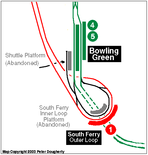
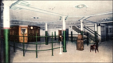
Bowling Green station serves the express trains from the IRT East Side line heading to/from Brooklyn. The station layout is unusual; it has a full length island platform, a side platform slightly offset on the eastern (northbound) side, and a quarter-length island platform on the western (southbound) side. Only the island platform is original construction, the rest were added later. Now, northbound trains open their doors on the right side of the train, onto the eastern side platform; southbound trains open their doors on the left side of the train onto the island platform. A railing runs the length of the island platform along the northbound track face. The short southbound-side platform is abandoned; so one could consider the station now having two tracks and two side platforms. The diagram below will more clearly illustrate the platform arrangement.
So why is this station so unusual? An overview of the service patterns at this station should make it clear. The station opened in July 1905 with only the island platform, and as of yet, no service to Brooklyn. Express trains from the East Side line entered the station from the north, stopped at Bowling Green, then circled the "Battery Loop" to South Ferry station, returning northbound and stopping at Bowling Green on their uptown journey. (Yes, South Ferry was built as part of the East Side line, and not of the IRT West Side/7th Ave. Line of which it is now primarily a part.)
South of Bowling Green, the Battery Loop consisted of one main track (connecting the downtown side of Bowling Green to the uptown side); one station on this loop track (South Ferry, with a single side platform on the outside of the loop), and a second inner loop track used for layups, storage, disabled trains, etc., and provision for the two main tracks to pass under the loop to Brooklyn.
In January, 1908, the tunnel to Brooklyn opened, and the initial service pattern had some express trains running to Borough Hall and some terminating at South Ferry via the Battery Loop. Demand for Brooklyn service was immediately higher than this service pattern permitted and it was necessary to run all rush hour trains through to Borough Hall. So, to provide rush hour service to South Ferry, construction started February 23, 1909 on the strange, short side platform on the west side of the Bowling Green station, and a new trackway connecting into the Battery Loop. Completed in April, 1909, shuttles then provided all rush hour service to South Ferry using this short platform. Off-peak trains continued to circle the South Ferry loop (and still do, although the terminating trains from the East Side line use the inner track and do not stop at South Ferry).
In 1918, the completion of the IRT West Side line from Times Square to South Ferry created a second connection into the Battery Loop. The West Side service began using the South Ferry station as its southern terminal. To continue providing the shuttle service, South Ferry had a second platform face added on the inside of the loop along the second track (the one formerly used only to turn or layup trains mentioned above.) The tracks are arranged so that the shuttle train enters and South Ferry Inner and returns in the same direction from which it came, without fouling the West Side service on the outer track.
The shuttle operation was discontinued in 1977 due to budget cuts, yet the platform and wall were renovated anyway in 1978. The 1978 renovation covered over original Heins & LaFarge mosaic "tapestries" that were along the side walls.
One more piece of Bowling Green requires explanation, the side platform on the eastern (northbound) side. This was built as part of the 1970s renovations, due to high passenger volume on the island platform. Additional exits were required from the island platform; building the side platform allowed for an underpass to be built, with exits to the street from the side platform. This funneled some of the traffic away from the headhouse exit at the south end. The fare control now consists of the restored headhouse entrance at the south end, which serves only the island platform, and various other entrances that lead to the eastern side platform and down to a large fare control gate area in the underpass.
 Photo by: David Pirmann |
 Photo by: David Pirmann |
 Collection of: Collection of nycsubway.org |
 Photo by: John Dooley |
 Photo by: Robbie Rosenfeld |
| More Images: 1-50 51-99 | ||||
Wall Street
Artwork Lariat Seat Loops (James Garvey, 1997)
45 Two tracks, two side platforms slightly offset from each other, with glossy blue tile over the original white. The standard IRT name tablet mosaics have been preserved and incorporated into the blue tile; fancy ceiling accents have been preserved as well. On the southbound platform is a wooden token booth and a ticket chopper, wooden restroom doors on each side, and a mosaic of the "wall" is on the rear wall. There is a crossunder about midway along the length of the stations, and a lesser-used one at the north end. At street level are faux kiosks on the southbound side. Exits are located at Broadway at Thames Street, and Broadway between Rector and Exchange Place. A long underground passageway exists outside the fare control which connects to the Broad Street station of the BMT Nassau Street-Jamaica Line. This passageway also leads to Chase Manhattan Plaza and and the old Equitable Building.
 Photo by: Robbie Rosenfeld |
 Photo by: David-Paul Gerber |
 Photo by: David-Paul Gerber |
 Photo by: Stacy Vairo-National Register of Historic Places filing |
 Photo by: Stacy Vairo-National Register of Historic Places filing |
| More Images: 1-50 51-74 | ||||
Fulton Street
Artwork Astral Grating (Nancy Holt, 1987), Marine Grill Murals, 1913 (Frederick Dana Marsh, 2000)
Transfer to BMT Nassau Street-Jamaica Line, IRT West Side Line, IND 8th Avenue Line
45![]() Fulton Street is a local station with two tracks and two side platforms, under Broadway
between Fulton Street (north) and Cortlandt Street (south). This is
the first station of the IRT Brooklyn Extension program, which opened
a few months after the IRT Main Line north of City Hall, and the first
subway station to reach as far south in Manhattan as Fulton Street.
Fulton Street is a local station with two tracks and two side platforms, under Broadway
between Fulton Street (north) and Cortlandt Street (south). This is
the first station of the IRT Brooklyn Extension program, which opened
a few months after the IRT Main Line north of City Hall, and the first
subway station to reach as far south in Manhattan as Fulton Street.
The station has many ornate decorative elements, including a plaque depicting the steamboat built by Robert Fulton, fancy terra-cotta "F" plaques with greek frets, marble panels, and mosaic name tablets. The southbound platform also incorporates an ornate entrance to 195 Broadway which features fluted columns, engraved metal signs, ornate railings, and some blacked-out display windows. This station is now a registered New York City landmark. There are exits at Fulton Street and Dey Street on the southbound side, and Fulton Street and John Street on the northbound side. The transfer corridor to the other Fulton Street stations and the new Fulton Street Transit Center headhouse runs easterly from here under Fulton Street.
The Fulton Street Transit Center is the MTA's marketing name for a new headhouse and updates to the transfer corridors at the four Fulton Street stations. Some relative depths of stations in the Fulton Street Transit Center complex are as follows, +/- 10 feet.
- IND Platforms: 60 feet
- IRT 2/3 Fulton Street: 50 feet
- BMT Northbound Fulton Street: 50 feet
- BMT Southbound Fulton Street: 20 feet
Artwork Astral Grating (Nancy Holt, 1987), Marine Grill Murals, 1913 (Frederick Dana Marsh, 2000)
 Photo by: Richard Brome |
 Photo by: Al Bennett, Jr. |
 Photo by: Andre Samuel |
 Photo by: Nicholas Noel |
 Photo by: Nicholas Noel |
| More Images: 1-50 51-68 | ||||
City Hall
City Hall Station, situated on a loop of track in front of City Hall, was the original southern terminal of the Interborough Rapid Transit subway. The site of the 1900 groundbreaking, this station was designed to be the showpiece of the new subway. Unusually elegant in architectural style, it is unique among the original IRT stations. The platform and mezzanine feature Guastavino arches and skylights, colored glass tilework, and brass chandeliers.
The curved platform is about 400' feet long, which is the length of a five car IRT train minus the front and rear doors as was the IRT's standard design for a local station when it was constructed. In the center of the platform is an archway over stairs leading to the mezzanine. On each side of the stairway, there is a glass tile "City Hall" sign, and a third is on the archway above the stairs. No other signs like these were placed in the other IRT. stations of the era; the lettering is quite unique, as is the deep blue and tan glass tiling. The arched ceiling of the platform area has simple brass light fixtures along its length.
When City Hall Station opened, plaques were hung on the track-side wall commemorating the Interborough Rapid Transit company and honoring the Rapid Transit Subway Construction Co.. The plaques listed the directors, engineers, and financiers, including August Belmont, Cornelius Vanderbilt, and John D. McDonald. These plaques were removed when the station was closed, and relocated to the Brooklyn Bridge station, where they hung near a token booth until 1995. As of early 1996, the plaques are back in their original positions on the trackside wall. Contrary to popular rumor, there was no plaque here honoring Alfred Ely Beach's early pneumatic subway.
The mezzanine featured a wooden ticket booth and two stairways to the street. The ticket booth is long gone. The complex green, tan, and white tiling pattern on the ceiling meets in the four corners of the vault over the mezzanine.
City Hall Station opened along with the rest of the Interborough's first subway line on October 27, 1904. It was immediately clear that expansion of the subway system would be necessary and additional lines were built. But ever-increasing ridership eventually required the Interborough's five-car local stations to be lengthened to accommodate longer trains, and so the IRT underwent an extensive program of station lengthening in the 1940s and early 1950s.
City Hall, due to its architecture and its being situated on a tight curve, was deemed impractical for lengthening. The new longer trains had center doors on each car, and at City Hall's tight curve, it was dangerous to open them. It was decided to abandon the station in favor of the nearby Brooklyn Bridge station, and so City Hall was closed to passenger service on December 31, 1945. The street entrances were sealed and the skylights covered over.
City Hall Station was never really an important one in terms of passenger use even when it was open; the nearby Brooklyn Bridge station was heavily used as it served both local and express trains, and the Brooklyn Bridge streetcar terminal was above.
While the station may be closed, and very few straphangers have actually seen it, the track on which City Hall Station is located is not abandoned. The #6 trains still pass through it on their way northbound, reversing direction using the loop for the journey back to the Bronx. In fact, to get to City Hall station, one must ride on an out-of-service #6 train. To get out, the motorman would key open a a single end door to allow visitors to step carefully out onto the platform. First-time visitors are awe-struck at the station's huge glass and brick arches and tiling. From time to time the NY Transit Museum has tours of this station, but these have been suspended due to perceived security risks in the area around City Hall.
Plans to open the station as an extension of the New York Transit Museum were mostly shelved due to recent security measures restricting access to the areas around City Hall. (These measures were in fact in place prior to 9/11/2001.) The station was spruced up for the October, 2004 IRT Centennial celebration. The skylights were uncovered, lighting fixed or replaced, and a stairway to the street reopened. A VIP ceremony was held there on October 27, 2004, and for a few hours after, the station was open to the public once again. It has remained closed since.
See Also Abandoned Stations - City Hall
 Diagram from the I.R.T. commemorative book The New York Subway: Its Construction and Equipment, shows the relative locations of Brooklyn Bridge and City Hall stations. |
 Another diagram of the Brooklyn Bridge and City Hall loop and station elevations. |
 Tablet, City Hall Station. "This First Municipal Rapid Transit Railroad of the City of New York Suggested by the Chamber of Commerce, Authorized by the State, Constructed by the City." |
 Tablet, City Hall Station. "Staff of the Chief Engineer." |
 Tablet, City Hall Station. "Rapid Transit Subway Construction Co." |
 Photo by: David Pirmann |
 Photo by: Richard Panse |
 Photo by: David Pirmann |
 Collection of: David Pirmann |
 Photo by: David Pirmann |
| More Images: 1-50 51-100 101-138 | ||||
Brooklyn Bridge/City Hall
Artwork Buildings, Boats, and a Bridge (Students of PS 126 and PS 20), Cable Crossing (Mark Gibian, 1996)
Transfer to BMT Nassau Street-Jamaica Line
456![]() Express station with four tracks and two island platforms in use, two
side platforms abandoned. The station has been recently renovated,
with new tile (poorly approximating original IRT tile) and
ADA-compliant elevator access.
Express station with four tracks and two island platforms in use, two
side platforms abandoned. The station has been recently renovated,
with new tile (poorly approximating original IRT tile) and
ADA-compliant elevator access.
Brooklyn Bridge/City Hall station is the southern terminal of the East Side IRT local service, assuming this role from the City Hall Loop station in 1945. South of the station, the downtown local track splits into three tracks. The right-most leads into the City Hall Loop (and thence returns to the uptown side of this station). The other two are layup tracks parallel to the downtown express track. Until the 1960s they merged into the downtown express track north of Fulton Street station but since then they are spurs ending a little ways north of Fulton St. Trains are occasionally stored there.
The Brooklyn Bridge station has a number of abandoned areas as construction and service patterns have required changes to be made to the station. In addition to the two existing island platforms, there are two short local platforms on the outer edges of the station. These local platforms were built to the 5-car length of original IRT local trains presumably to accommodate extra passenger volume. (Similar platforms were built at the express stations at 14th Street and 96th Street.) These side platforms did not see much use as they were located at express stations that required transfer via the island platforms, and, as the trains were lengthened to their current 10-car length it was impractical to lengthen both these small side platforms and the island platforms. They were closed in 1910 after only six years in operation and walled off along the platform edges.
The side platform on the southbound is now home to some electrical equipment and a backup control tower for the Brooklyn Bridge interlocking. This tower is functional but not normally used, because the Grand Central tower is the primary control point for the whole line. The interlocking board can be seen through a window along the wall along the southbound local trackway. The south end of the downtown side platform is still visible near the dispatcher's booth on the downtown island platform.
There are also some closed portions at the south ends of the existing express platforms. During the station lengthening projects it was easier to lengthen the express platforms to the north. The curves at the south end proved impossible to rework so the station was lengthened northward (allowing Worth St. to be abandoned), and the curved southern ends of the express platforms closed. Gap fillers and original mosaic tiles remain in the closed ends.
 Present-day diagram of the Brooklyn Bridge and City Hall loop and station elevations. Click to enlarge. |
 Detailed construction plan of the Brooklyn Bridge station as originally built, from the book The New York Subway: Its Construction and Equipment. |
Another diagram of the Brooklyn Bridge and City Hall loop and station elevations. Click to enlarge. |
 Photo by: Joe Testagrose |
 Photo by: Chao-Hwa Chen |
 Photo by: David Pirmann |
 Photo by: Bill E. |
 Photo by: Wilfredo Castillo |
| More Images: 1-50 51-100 101-150 151-188 | ||||
Worth Street
Worth Street Station was closed to passengers in 1962, due to the platform lengthening at Brooklyn Bridge. In fact, from 1962 to 1995, Brooklyn Bridge/City Hall was named Brooklyn Bridge/Worth Street on platform signs. This station underlies the sidewalk on the west side of Foley Square. The subway tunnel runs very close to the foundation wall of the lower level of Federal Plaza, but the station does not intrude into footprint of the plaza.
See Also Abandoned Stations - Worth Street
 Photo by: Brian Weinberg |
 Photo by: Brian Weinberg |
 Photo by: Brian Weinberg |
 Photo by: Brian Weinberg |
 Collection of: David Pirmann |
| More Images: 1-7 | ||||
Canal Street
Artwork Sorry, no artwork here.
Transfer to BMT Nassau Street-Jamaica Line, BMT Broadway Line
6![]() Canal Street is a busy station in the vibrant Chinatown
neighborhood. It is a local station with two side platforms alongside
four tracks. Part of a large complex, transfer is provided here to the
BMT Nassau St. and BMT Broadway subway lines. Due to platform
lengthening in the 1950s, there are two distinct sections of this
station. The original portion has tile covered I-beams with small name
tablets and small "C" mosaics in tile band along tops of walls, and an
ornamental ceiling. The new portion had 1950s green tile at the ends
of the platforms, but a late 1990s-early 2000s renovation has replaced
this with a uniform white tile along the whole platform wall. IND-type
directional "To Canal Street" signs are also present.
Canal Street is a busy station in the vibrant Chinatown
neighborhood. It is a local station with two side platforms alongside
four tracks. Part of a large complex, transfer is provided here to the
BMT Nassau St. and BMT Broadway subway lines. Due to platform
lengthening in the 1950s, there are two distinct sections of this
station. The original portion has tile covered I-beams with small name
tablets and small "C" mosaics in tile band along tops of walls, and an
ornamental ceiling. The new portion had 1950s green tile at the ends
of the platforms, but a late 1990s-early 2000s renovation has replaced
this with a uniform white tile along the whole platform wall. IND-type
directional "To Canal Street" signs are also present.
Some relative depths of stations in the Canal Street complex are as follows, +/- 10 feet.
- BMT Broadway platforms, 40 feet below street
- BMT bridge line platform, 50 feet below street
- IRT subway platform, 20 feet below street
- BMT Nassau St. subway platform, 20 feet below street
 Photo by: David Pirmann |
 Photo by: Bill E. |
 Photo by: Robbie Rosenfeld |
 Photo by: Bill E. |
 Photo by: Roberto C. Tobar |
| More Images: 1-29 | ||||
Spring Street
Artwork Sorry, no artwork here.
6 Local station with two side platforms alongside four tracks, and one center disused trackway. Fare control is at platform level, and the station was not designed with a pedestrian underpass between the platforms. The station retains the typical large and small IRT mosaics in the original portion. The portion of the station added during the various platform lengthening projects has simple white tile.
The fifth center track, installed as part of the original construction and depicted in early publicity photos, is reported to have been disconnected by 1906. Its intended function is unclear. The locations of switches to and from this center track to the express tracks can be seen at one point along the center track walls. A mechanical room is now located in the trackway at the south end between the two express tracks.
- Plaques: Small "S" cartouches. Atlantic Terra Cotta, 1904.
- Name tablets: Two styles of mosaic tablet. Large original ones, Heins & LaFarge, 1904. Small ones not original. See photos below.
- Other: Small "S" mosaics in tile band along tops of walls.
 Photo by: Wayne Whitehorne |
 Photo by: Detroit Publishing Co. |
 |
 Photo by: Roberto C. Tobar |
 Photo by: Mike L. |
| More Images: 1-36 | ||||
Bleecker Street
Artwork Signal (Mel Chin, 1998), Hive (Leo Villareal, 2012)
Transfer to IND 6th Avenue Line
6![]() Bleecker Street station features typical IRT mosaics with two styles
of small "Bleecker Street" mosaics. The fare control is at platform
level. Until the full transfer to the IND 6th Avenue Line (at
Broadway/Lafayette Street) opened in 2012, there was a very large
offset between the platforms, and there was no crossover or
crossunder.
Bleecker Street station features typical IRT mosaics with two styles
of small "Bleecker Street" mosaics. The fare control is at platform
level. Until the full transfer to the IND 6th Avenue Line (at
Broadway/Lafayette Street) opened in 2012, there was a very large
offset between the platforms, and there was no crossover or
crossunder.
MTA New York City Transit hired a joint venture of Weidlinger Associates and Lee Harris Pomeroy Architects to design an ADA compliant, complete bidirectional transfer facility. Beginning in 2007, following the joint venture's engineering plans, the contractor, M.A. Angeliades, extended the uptown IRT platform 300 feet to align it with the IND station, and constructed a central stairwell and elevator shafts to connect the IRT platform to the IND platforms beneath it. Angeliades added elevators to provide access to Crosby and Houston Streets and an entrance at Mulberry Street.
A new artwork entitled Hive, by artist Leo Villareal, is over the staircase leading to the uptown IRT platform. The artwork was inspired by John Conway's famous mathematical formula "Life". The LED lighting are programmed to flash with different speeds and intensity depending on how busy the station is. According to Sandra Bloodworth, the director of MTA Arts for Transit, the installation evokes not only the subway system's "movement and transportation, but also that process of life."
The reconstructed and historically landmarked station is also graced with terra cotta finishes. The budget for creating the new transfer grew from $91 million to $135 million, in part because of increases in construction costs, and in part because the MTA learned it would have to relocate a water main at Houston Street and shore up an adjacent unstable building whose owners could not pay for repairs. The completion target of 2010 was pushed back repeatedly; the MTA finally confirmed that the transfer would be open in August 2012.
Reconstruction of the station included repairs to all systems, reconstruction of control areas, and relocation of major buried utilities. Extension of the IRT uptown platform involved replacing the tunnel wall; constructing a new platform, roof, and tunnel duct manhole; and re-supporting the tunnel roof on the new platform roof. Excavation was necessary along an existing IRT tunnel box structure adjacent to an existing six-story building, garage, and giant billboard, which had foundations that had to be deepened and stabilized.
 Photo by: David Sagarin/Historic American Engineering Record |
 Photo by: Bill E. |
 Photo by: Wilfredo Castillo |
 Photo by: Robbie Rosenfeld |
 Photo by: Roberto C. Tobar |
| More Images: 1-50 51-62 | ||||
Astor Place
Artwork Untitled (Milton Glaser, 1986)
6

Local station with two offset side platforms alongside four tracks. The fare control is at platform level, and there are indications of a sealed-up crossunder, long since closed. The station's decoration includes plaques depicting beavers, in honor of John Jacob Astor, who had made his fortune in the beaver pelt trade. The beaver plaques and station name tablets are original decoration made by the Grueby Faience Co.
Astor Place station was built in large part under what had been private property along the west side of Astor Place. Several buildings were demolished to make way for the station accounting for today's odd shape of Astor Place. In the pedestrian island where the entry to the northbound station platform is located, there is a reproduction of the famous IRT kiosks.
The heavy brick-faced square columns on the downtown platforms support the old John Wanamaker (now K-Mart) store above them. The octagon windows on the brick wall of the platform were the store's showcases. K-Mart has reopened a direct entrance to their store from the southbound platform, which had been sealed for many years after the demise of the Wanamaker's store at that location.
Astor Place was planned to be a transfer point for the 9th Street branch of the Hudson & Manhattan Railroad (today's PATH). The H&M station would be at about the same level as the IRT on 9th Street between Broadway and Cooper Square abutting the west wall of the Astor Place station. The reservation for this branch is still in force as of the early 1980s; an apartment house on 9th Street was prevented from certain basement reconstruction because the work would compromise the right-of-way. Greenwich Village transit activists suggested building this spur to provide some cross-Village transit but by now it seems impractical and unlikely.
 Photo by: IRT Company |
 Photo by: Roberto C. Tobar |
 Photo by: Peter Ehrlich |
 Photo by: David Blair |
 Photo by: Bernard Chatreau |
| More Images: 1-50 51-82 | ||||
14th Street/Union Square
Artwork Chairs (Jennifer Cecere, 1995), Framing Union Square (Mary Miss, 1998), Paradise (Chiho Aoshima, 2005)
Transfer to BMT Canarsie Line, BMT Broadway Line
456 14th Street/Union Square is an express station, with four tracks, two island platforms (in service), and two side platforms (abandoned). The uptown and downtown platforms are offset from each other north to south, and are slightly curved. Gap filling moveable platforms are automatically operated via proximity sensors mounted on the outside wall when trains arrive. There is a mezzanine above the platforms that provides transfer opportunity to the BMT lines.
This station has two abandoned side local platforms. The northbound one is visible through windows, bordered with wide, bright red frames. The space is being used as storage and utility rooms.
On August 29, 1991, an accident occurred just north of the station, killing five people in one of the worst wrecks since the [[Malbone Street Wreck (New York Times, 1918)|Malbone Street Disaster]] of 1918. The train operator, Robert Ray, had been overshooting platforms on the entire run. At 14th Street the train was to be shifted to the local track due to repairs. He had been running the train at 40 MPH in a 10 MPH zone and took the switch so fast that only the front of the first car made the crossover. The third and fourth cars ended up perpendicular to the tracks, having sheared off support columns and split in half. The line suffered heavy damage and service was disrupted for six days as transit workers toiled around the clock to clean up the wreckage. The entire infrastructure, including signals, the switches, track, roadbed, cabling, and 23 support columns needed to be replaced. The motorman Ray was sentenced to 15 years in prison for the worst subway accident since 1928.
The wreck occurred between 18th Street and Union Square on the downtown side at the entry to a former pocket track. Union Square and 72nd Street on the IRT West Side line had extra tracks on the approach to the station. These were between the incoming local and express track and were one old IRT train length long. The idea was to have a 'stacking' track where a train could be held momentarily until the platform cleared for it to enter the station. The track here and at 72nd Street were rendered useless when train lengths grew beyond their capacity. When the damage from the 1991 wreck was repaired the crossing was not made more gentle even though the stacking track here was removed.
 Photo by: David Pirmann |
 Photo by: David Pirmann |
 Photo by: Filip Matuska |
 Photo by: Richard Panse |
 Photo by: Chao-Hwa Chen |
| More Images: 1-50 51-93 | ||||
18th Street
Local station with two side platforms alongside four tracks. The 18th Street station was open from 1904 to 1948, and was closed due to the platform lengthening project at 14th Street (you can see the 14th St. station just down the tracks).
See Also Abandoned Stations - 18th Street
 Photo by: David Pirmann |
 Photo by: David Pirmann |
 Photo by: David Pirmann |
 Photo by: David Pirmann |
 Collection of: David Pirmann |
| More Images: 1-12 | ||||
23rd Street
Artwork Long Division (Valerie Jaudon, 1988)
6![]() 23rd Street is a local station with two side platforms alongside four
tracks. There are IND-type signs indicating the way to 22nd and 23rd
Sts. An ornate fare control grille on the southbound side is actually
an artwork entitled Long Division, by artist Valerie Jaudon,
which was installed during station renovations in 1988. The station
features a back-lit "23rd Street/Park Avenue South" sign at the
platform-level fare control. There is a low tiled wall at the 22nd
street end which is a probable remnant of a closed crossunder.
23rd Street is a local station with two side platforms alongside four
tracks. There are IND-type signs indicating the way to 22nd and 23rd
Sts. An ornate fare control grille on the southbound side is actually
an artwork entitled Long Division, by artist Valerie Jaudon,
which was installed during station renovations in 1988. The station
features a back-lit "23rd Street/Park Avenue South" sign at the
platform-level fare control. There is a low tiled wall at the 22nd
street end which is a probable remnant of a closed crossunder.
 Photo by: Detroit Publishing Co. |
 Collection of: Ed Levine |
 Photo by: Robbie Rosenfeld |
 Photo by: Robbie Rosenfeld |
 Photo by: Roberto C. Tobar |
| More Images: 1-32 | ||||
28th Street
Artwork 7 waves 4 twenty eight (Gerald Marks, 1996), Roaming Underfoot (Nancy Blum, 2019)
6![]()

28th Street is a local station with two side platforms alongside four tracks. The local tracks are raised above the express tracks to facilitate easier braking and acceleration, as described in the book The New York Subway: Its Construction and Equipment (1904). The fare control is at platform level and does not currently provide for a crossunder or crossover, however there is a closed crossunder complete with railings and a blacked out sign indicating its location. The token booth is unusual in that instead of a standalone structure, it is built into the tile wall. The station's ornamentation includes an unusual back-lit station name sign at the fare control.
ADA accessibility at this station is presently (2025) limited to downtown trains only.
 Photo by: Wayne Whitehorne |
 Photo by: Detroit Publishing Co. |
 Photo by: Detroit Publishing Co. |
 Photo by: Robbie Rosenfeld |
 Photo by: David Pirmann |
| More Images: 1-31 | ||||
33rd Street
Artwork Lariat Seat Loops (James Garvey, 1997)
6 33rd Street is a local station with two side platforms alongside four tracks. The local tracks are raised above the express tracks to facilitate easier braking and acceleration, as described in the book The New York Subway: Its Construction and Equipment (1904). The fare control is at platform level. The decoration at platform level features terra-cotta eagle plaques, similar to those at Brooklyn Bridge and 14th Street. This station was recently renovated.
 Photo by: Robbie Rosenfeld |
 |
 Photo by: Robbie Rosenfeld |
 Photo by: Filip Matuska |
 |
| More Images: 1-25 | ||||
Grand Central
Artwork Title unknown, I dreamed a world and called it love (Jim Hodges, 2020)
Transfer to IRT Flushing Line, IRT Times Square-Grand Central Shuttle
456![]()

Grand Central is an express stop and the first station along the line from Brooklyn Bridge built as part of the Dual Contracts. During its construction it was referred to as the "Diagonal Station", owing to its position on a diagonal connecting the IRT Contract I subway under Park Avenue with the new Dual Contracts subway under Lexington Avenue. (Since then, the subway south of Grand Central has come to be known as the "Lex" even though it runs under Park Avenue and various other thoroughfares.) The station is roughly positioned beginning at 41st Street & Park, running under the buildings along 42nd Street between Park & Lexington, and ending just north of 42nd Street at the west side of Lexington. A December, 1918 article published in the Public Service Record, Design of the Diagonal Station and Connection, details the construction, and a later single line diagram (PDF) gives a scale representation of the track and platform layout. The station platforms are decorated with what will be recognized as "typical Dual Contracts" name tablets, icons, and "runner" mosaics along the track-side walls. The icon in this case is a stylized steam locomotive, apropos to the station's location under Grand Central Terminal (which in its early days indeed had steam powered trains). MTA Metro-North's renovations of Grand Central Terminal included an air-conditioning project, and this was extended to the usually extremely warm IRT subway platforms. Chilled water-based air coolers are located at several points along the platforms, making Grand Central the only artificially cooled station on the New York City Subway. The platform's massive columns and beams support part of Grand Central Terminal and the office towers next to it.
The station offers transfer to the IRT Flushing, Queens line as well as the Shuttle to Times Square. The complex also included provisions for a terminal station serving a future extension of the Hudson & Manhattan (PATH) railroad's 6th Avenue line, planned in the early part of the century but never constructed. As a result the station is extremely complex, with a mezzanine above the IRT Lexington line platforms which has direct access by escalator to the Flushing line. There is also a cross-under below the Lexington line platforms offering an easier transfer path to the Flushing line. The mezzanine features as artwork a correctly-oriented compass rose inlaid on the floor.
The Grand Central complex is home of the master tower which controls the entire East Side IRT. from lower Manhattan to 125th Street. The interlocking control is quite a sight. The board board shows the status of all of the signals and switches, and roughly indicates the train locations along the East Side IRT. In the photo of the board below, the City Hall loop is on the top track diagram on the far left, and at the close right is Grand Central. The lower tracks indicate from Grand Central north to 125th Street.
North of Grand Central, the express tracks descend to a lower level, and the line continues north in a 2-over-2 configuration.
Some relative depths of stations in the Grand Central complex are as follows, +/- 10 feet.
- Shuttle, 20 feet below street
- Lexington/East Side Subway Platforms, 50 feet
- Flushing/#7 Subway Platforms, 80 feet
- Metro North, Upper Level, 20 feet
- Metro North, Lower Level, 60 feet
 Photo by: David Pirmann |
 Photo by: Roberto C. Tobar |
 Collection of: Collection of nycsubway.org |
 Photo by: Robbie Rosenfeld |
 Photo by: Lee Winson |
| More Images: 1-50 51-100 101-143 | ||||
51st Street
Artwork Tunnel Vision (Nina Yankowitz, 1989), Passing Through (Al Held, 2004)
Transfer to IND Queens Boulevard Line
6![]() 51st Street a local station with two side platforms alongside two
tracks (the express tracks are on a lower level). It is the sixth
busiest station in the subway system. This station features beige
brick over the original tile but the standard IRT mosaics were saved.
There is a crossunder at the north end and connections via a long
passageway to the IND Queens Boulevard/53rd Street line station at
Lexington Ave. The fare control is seven steps up from the platform
level, and the platforms themselves are approximately 60 feet below
street level.
51st Street a local station with two side platforms alongside two
tracks (the express tracks are on a lower level). It is the sixth
busiest station in the subway system. This station features beige
brick over the original tile but the standard IRT mosaics were saved.
There is a crossunder at the north end and connections via a long
passageway to the IND Queens Boulevard/53rd Street line station at
Lexington Ave. The fare control is seven steps up from the platform
level, and the platforms themselves are approximately 60 feet below
street level.
 Photo by: Richard Panse |
 Photo by: Peter Ehrlich |
 Photo by: Roy Freeman |
 Photo by: Richard Panse |
 Photo by: Robbie Rosenfeld |
| More Images: 1-45 | ||||
59th Street
Artwork Blooming (Elizabeth Murray, 1996)
Transfer to BMT Broadway Line
456

59th Street is an express station with two levels each with two side plaforms alongside two tracks. It was built as a local-only station with side platforms (now the upper level). The express tracks, which run underneath the BMT 60th St. tunnel, had platforms added later and were opened on November 15, 1962. The express platforms were added to reduce congestion at Grand Central and to provide another connection to Queens trains via the BMT. This complex is on three levels, with the IRT local on top, the BMT Queens trains in the middle, and the IRT express on the bottom.
This station used to have all green tile which has been covered up except for one "59th Street" sign near the south end of the northbound platform. There are whimsical stylized coffee cups and slippers mosaics in varied colors at random spacing near the stairways to mid and upper levels.
 Photo by: Steffen Petrasch |
 Photo by: Roberto C. Tobar |
 Photo by: Roberto C. Tobar |
 Photo by: Roberto C. Tobar |
 Photo by: Bernard Chatreau |
| More Images: 1-40 | ||||
68th Street - Hunter College
Artwork Sorry, no artwork here.
6![]() 68th Street/Hunter College is a local station with two side platforms
alongside two tracks. The platforms feature original Dual Contracts
mosaic tiling, with "68" tablets and name tablets reading "68th
STREET-HUNTER COLLEGE". At the ends of the platforms, the tiling is
different where the station was extended in the 1950s. The stairs
leading to the mezzanine are near the south end. The mezzanine was
renovated in the 1990s and has stainless steel fare control rails, a
glass-windowed crossover/waiting area, and red accent stripe in the
tiling. The northern half of the station without the mezzanine has
very high ceilings.
68th Street/Hunter College is a local station with two side platforms
alongside two tracks. The platforms feature original Dual Contracts
mosaic tiling, with "68" tablets and name tablets reading "68th
STREET-HUNTER COLLEGE". At the ends of the platforms, the tiling is
different where the station was extended in the 1950s. The stairs
leading to the mezzanine are near the south end. The mezzanine was
renovated in the 1990s and has stainless steel fare control rails, a
glass-windowed crossover/waiting area, and red accent stripe in the
tiling. The northern half of the station without the mezzanine has
very high ceilings.
 Photo by: Wayne Whitehorne |
 Photo by: Leonard Wilson |
 Photo by: Danny Molina |
 Photo by: Roberto C. Tobar |
 Photo by: Bernard Chatreau |
| More Images: 1-30 | ||||
77th Street/Lenox Hill Hospital
Artwork 4 Seasons Seasoned (Robert Kushner, 2004)
6 77th Street/Lenox Hill Hospital is a local station with two side platforms alongside two tracks. The fare control is ten steps up from the platform level, and does not provide a crossover or crossunder. Some old wall lights exists but most are gone or in disrepair. Emergency exits from the lower level express tracks are on both platforms.
 Photo by: Wayne Whitehorne |
 Photo by: Wayne Whitehorne |
 Photo by: Robbie Rosenfeld |
 Photo by: Roberto C. Tobar |
 Photo by: Roberto C. Tobar |
| More Images: 1-23 | ||||
86th Street
Artwork Happy City (Peter Sis, 2004)
456![]() 86th Street is an express station with two levels, each with two side
platforms alongside two tracks. The station has its fare control at
platform level, with no free crossover/under provided. The station was
renovated in the 1990s and mosaic artwork was installed in the stairways.
This station serves the surrounding neighborhood known as Yorkville,
which once had a large German-American community. The area has
changed and the ethnic stores are gone, but once a year, the past
returns during the annual Steuben Day Parade.
86th Street is an express station with two levels, each with two side
platforms alongside two tracks. The station has its fare control at
platform level, with no free crossover/under provided. The station was
renovated in the 1990s and mosaic artwork was installed in the stairways.
This station serves the surrounding neighborhood known as Yorkville,
which once had a large German-American community. The area has
changed and the ethnic stores are gone, but once a year, the past
returns during the annual Steuben Day Parade.
ADA accessibility at this station is presently (2025) limited to Uptown #6 trains only.
 Photo by: Robbie Rosenfeld |
 Photo by: Richard Panse |
 Photo by: David Pirmann |
 Photo by: Roberto C. Tobar |
 Photo by: Lee Winson |
| More Images: 1-39 | ||||
96th Street
Artwork City Suite (Laura Bradley, 1994)
6 96th Street has a crossover and a mosaic in the mezzanine entitled City Suite, commissioned in 1994. New "96th Street" mosaics abound and a window in the mezzanine overlooks the tracks, giving a view of oncoming trains from the south. The south end of the station features a rounded ceiling due to problems encountered during construction.
 Photo by: Professor J |
 Photo by: Roberto C. Tobar |
 Photo by: Eric Oszustowicz |
 Collection of: Frank Pfuhler |
 Photo by: Nicholas Noel |
| More Images: 1-35 | ||||
103rd Street
Artwork Neo-Boriken (Nitza Tufino, 1990)
6 103rd Street is a local station with two side platforms alongside four tracks, the express having risen from the lower level. The station has a mezzanine crossover and is renovated. The featured art work is a 1990 ceramic entitled Neo-Boriken by artist Nitza Tufino. Mosaics indicating uptown and downtown directions are also here.
 Photo by: Danny Molina |
 Photo by: Danny Molina |
 Photo by: Danny Molina |
 Photo by: Andre Samuel |
 Photo by: Robbie Rosenfeld |
| More Images: 1-27 | ||||
110th Street
Artwork Un Sabado en la Ciento Diez (A Saturday on 110th Street) (Manuel Vega, 1996)
6 110th Street is a local station with two side platforms alongside four tracks. Fare control at platform level and no crossover or crossunder is provided. There are standard IRT number and station name tile mosaics.
 Photo by: Robbie Rosenfeld |
 Photo by: Robbie Rosenfeld |
 Photo by: Danny Molina |
 Photo by: Roberto C. Tobar |
 Photo by: Peter Ehrlich |
| More Images: 1-12 | ||||
116th Street
Artwork In Everything There is a Season (Robert Blackburn, 2005)
6 116th Street is a local station with two side platforms alongside two tracks. (Between 110th St. and 116th St., the express tracks descend back to the lower level.) Fare control is at platform level and no crossover or crossunder is provided. This station has the standard IRT number and station name tile mosaics.
 Photo by: Wayne Whitehorne |
 Photo by: Robbie Rosenfeld |
 Photo by: Robbie Rosenfeld |
 Photo by: Roberto C. Tobar |
 Photo by: Jose Garrido |
| More Images: 1-8 | ||||
125th Street
Artwork Open Secret (Houston Conwill, 1986), Polyrhythmics of Consciousness and Light (Valerie Maynard, 2002)
Transfer to IRT Pelham Line, IRT Woodlawn Line, IRT White Plains Road Line
456![]()

125th Street is an express station on two levels, with two island platforms and four tracks, however the platforms are not arranged in typical express-on-one-level, local-on-the-other fashion. Here, the upper platform has express on the east track and local on the west track, and the lower level is opposite. This is done to easily separate traffic bound for the branch lines in the Bronx. There is an active tower at the north end of the northbound platform.
 Photo by: Robbie Rosenfeld |
 Photo by: Oren H. |
 Photo by: Ed Davis, Sr. |
 Photo by: Nicholas Noel |
 Photo by: Nicholas Noel |
| More Images: 1-46 | ||||
Sources
Many photos, route descriptions, and details of the construction progress of the subway lines can be found in: Report of the Board of Rapid Transit Railroad Commissioners in the City of New York, for the year ending... 1901, 1902, 1903, 1904, 1905, 1906; and Report of the Public Service Commission for the First District of the State of New York, for the year ending... 1907, 1908, 1909, 1910, 1911, 1912, 1913, 1914, 1915, 1916, 1917, 1918, 1919, 1920.
The New York Subway: Its Construction and Equipment (1904)
The New York Subway Souvenir (1904)
New Subways for New York: The Dual System of Rapid Transit (1913)
David Rogoff, "Contract I Construction", July 1962, revised July 1985, New York Division E.R.A.
Other articles as linked.
Page Credits
By David Pirmann and Peggy Darlington.